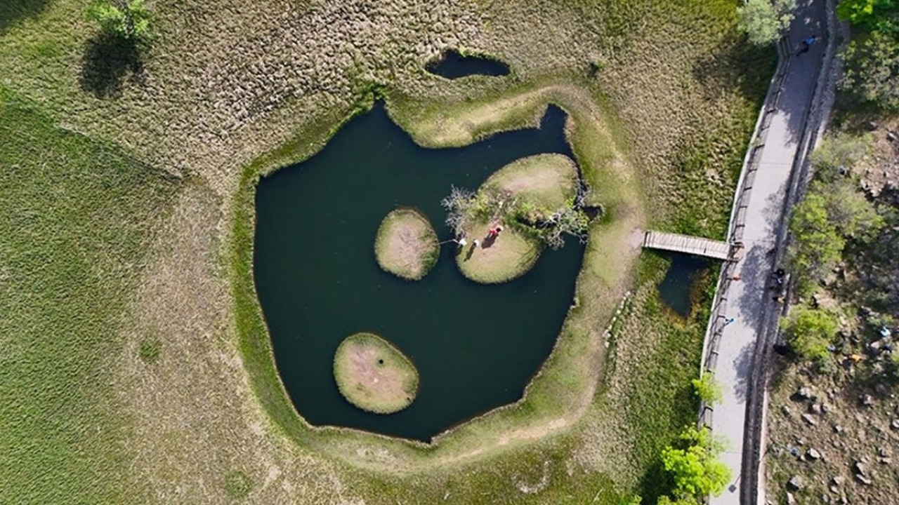

The Floating Islands (Yüzen Adalar) are a captivating natural phenomenon in Bingöl, specifically three unique plant islets that drift across the surface of Turna Lake. Located in the Aksakal hamlet of Hazarşah village, within Solhan district, these aren't your typical fixed landmasses. Instead, they're formed by an intricate network of intertwined plant roots and a peat layer that remains buoyant, shifting their position throughout the day with the whims of the wind. This remarkable area was designated a Nature Monument in 2003, encompassing approximately 38.4 hectares of protected land. Situated about 45 kilometers from Bingöl city center, it's a tranquil natural spot perfect for a refreshing break. This comprehensive guide covers the islands' formation, how to get there, the best times to visit, and other complementary attractions nearby.
Where Are the Floating Islands and What Makes Them Move?
The site is located along the highway connecting Bingöl city center to Muş, approximately 4.5 kilometers off the Solhan-Bingöl road. Turna Lake itself is a crater lake nestled in a flat basin, surrounded on three sides by hills. Despite its relatively small surface area, the lake plunges to depths exceeding 50 meters, and its water level remains remarkably consistent throughout the year. The three islets float independently on this water, separate from each other and the lakebed.
The Fascinating Story Behind Their Formation
The region's landscape was sculpted by the volcanic uplifts surrounding Bingöl. It's believed that the basin where the islets reside is linked to an ancient landslide. Over time, aquatic plants took root in the accumulated soil on the surface, and this vegetation cover expanded to blanket a significant portion of the lake. The cold, still waters prevent plant debris from decaying, allowing it to accumulate as a buoyant peat layer. When sections of this light layer break off, they continue to float without disintegrating. Since the wind carries these islets from one end of the lake to the other, the arrangement visitors see is unique with every visit.
Quick Facts
| Topic | Information |
|---|---|
| Location | Aksakal hamlet, Hazarşah village, Solhan district, Bingöl (Turna Lake) |
| Status | Floating Islands Nature Monument (2003, approx. 38.4 hectares) |
| Highlight | Three shifting plant islets on a crater lake |
| Best time to visit | Late May to September |
| Transportation | From Bingöl city center towards Muş highway, approx. 45 km and a one-hour drive |
| Suggested duration | Half-day, full-day with surrounding attractions |
| Difficulty | Easy, short lakeside walk |
What to Explore by the Lake?
Your visit will primarily involve strolling around the lake and observing the mesmerizing movement of the islets. A unique feature of the area is that when you step onto the islands, they gently drift like a raft. The surroundings offer designated viewing terraces, picnic spots, and areas for nature walks. Given its status as a nature monument, it's crucial to protect the vegetation, refrain from littering, and adhere to all warning signs.
Prime Viewing Spots for the Islets
The elevated sections of the shoreline and the dedicated viewing terrace provide excellent vantage points for a panoramic view of the lake. The islets' movement becomes more pronounced in the afternoon when the wind tends to pick up. For photography enthusiasts, early morning is ideal, as the still water surface offers crystal-clear reflections.
Lakeside Exploration and Birdwatching
The reedy shores of the lake create a favorable habitat for various water birds, making late spring and early autumn particularly rewarding for birdwatching. Given the lake's depth, caution is advised near the water's edge, especially for families with children.
Plateau Views and Scenic Walks
The grasslands surrounding the lake bear the distinctive character of a yayla (highland pasture), used by families engaged in animal husbandry during the summer months. Short walks can lead you to the edge of the plateau, offering stunning views. If you're looking to combine similar plateau and lake routes into a single itinerary, explore the diverse options available in our nature adventure tours.
Getting to Solhan from Bingöl
- From Bingöl city center, take the state highway heading towards Muş. Solhan is a key district stop along this route, and the approximately 45-kilometer drive takes about an hour.
- Turn off the highway at the "Yüzen Adalar" (Floating Islands) sign, heading towards Hazarşah village. The remaining distance to the main site is approximately 4.5 kilometers.
- For public transport, take a minibus from Bingöl bus terminal to Solhan, then arrange local transport from the district center for the final leg.
- Plan your return journey before nightfall, as lighting on the plateau road is limited.
Air Travel and Intercity Connections
Scheduled flights to Bingöl Airport operate on specific days of the week, so it's advisable to check flight times well in advance. Alternatively, airports and bus routes in neighboring provinces offer other travel options.
Beyond the Islands: What Else to See in Bingöl?
Since the Floating Islands can be explored in half a day, it's easy to combine your visit with other nearby attractions. The table below summarizes key points of interest and their distances from the city center.
| Attraction | Location | Distance from Center |
|---|---|---|
| Floating Islands (Turna Lake) | Solhan, Hazarşah village | Approx. 45 km |
| Abdulkadir Sarı Recreation Park | Center, Kaleönü neighborhood | Approx. 5-7 km |
| Ilıcalar thermal spa area | Town affiliated with center | Approx. 21 km |
| Çır Waterfall | Ilıcalar, Uzundere village | 8 km from Ilıcalar center |
| Genç district center | Genç | Approx. 21 km |
| Karlıova highlands | Karlıova | Approx. 70 km |
Çır Waterfall
Although often attributed to the Genç district, Çır Waterfall is actually located in Uzundere village, part of the Ilıcalar town, which is affiliated with Bingöl city center. The waterfall is 8 kilometers from Ilıcalar town center and can be reached via two different routes. The water cascades down the side of a rock mass known as Büyük Çır Taşı (Great Çır Stone), approximately 100 meters high. Late spring, when the water flow is at its peak, is an ideal time to visit. Be sure to wear sturdy, non-slip shoes, as the ground can be slippery.
Abdulkadir Sarı Recreation Park
Located in the Kaleönü neighborhood, approximately five kilometers along the Bingöl-Muş highway, this facility was established by the Provincial Special Administration between 1985 and 1986 within an expansive 111,000-square-meter area of fruit trees and poplars. It serves as a convenient short stop at the beginning of your day, as it's directly on the route when heading towards Solhan.
Ilıcalar: A Relaxing Thermal Break
Named after its hot springs, Ilıcalar is not a district but a charming town located approximately 21 kilometers from the city center. Its thermal spa facilities are a popular stop for those seeking relaxation after a long drive. During peak seasons, booking in advance is recommended to avoid waiting. For travelers keen to incorporate the city's historical fabric into their itinerary, our cultural tours offer a comprehensive starting point.
Best Seasons and Timing for Your Visit
| Period | Advantage | Note |
|---|---|---|
| Late Spring (May) | Lake level rises with snowmelt, wildflowers bloom | Mornings are cool, possibility of rain persists |
| Summer (June-August) | Clear weather, long daylight hours, easy highland roads | Midday can be hot, limited shaded areas |
| Autumn (September-October) | Tranquil atmosphere, changing colors, clear visibility | Days shorten early, evening temperatures drop |
| Winter (November-March) | Snow-covered plateau scenery | Snow and ice make roads challenging |
Dining and Accommodation Options
In Solhan district center, you'll find local eateries and bakeries catering to day-trippers. However, it's more practical to plan your overnight stay in Bingöl city center, which offers a wider selection of hotels. Highland products are a distinctive feature of the regional cuisine: Bingöl honey, for instance, was registered with a geographical indication by the Turkish Patent and Trademark Office in 2022 and became the first Turkish honey product registered with the European Union in 2024. Honey produced using the traditional "karakovan" (dark hive) method is still prevalent in the region.
- For breakfast, the registered Bingöl honey, local butter, and dairy products are highly recommended.
- For lunch, the artisan restaurants in the district center offer quick and delicious options.
- If picnicking, remember to bring your own water and waste bags, as there are no sales points at the site.
Those looking for itineraries centered around local cuisine can explore our gastronomy and event tours.
Essential Tips Before You Visit
- Opt for windy days; the movement of the islets is more noticeable then.
- Due to the altitude, evening temperatures drop quickly, so bring a light windbreaker.
- The reedy shoreline can be unstable, so avoid getting too close to the water's edge.
- There are no shops at the site, so purchase drinking water from the district center.
- Save your route on an offline map, as mobile signal strength can be inconsistent.
How Many Days for Your Trip?
The Floating Islands can comfortably be explored as part of a single-day itinerary. A balanced plan would involve departing from Bingöl city center in the morning, exploring the lake area before noon, and then heading towards Ilıcalar and Çır Waterfall in the afternoon. If you allocate two days, the Karlıova highlands can also be included in your program. For those extending their route to a neighboring province, our Muş attractions guide details the continuation of the same highway route. Crater lake enthusiasts can also compare similar geology with the Bitlis Nemrut Crater Lake guide.
Frequently Asked Questions 5
Where are the Floating Islands situated?
They are located on Turna Lake, within the Aksakal hamlet of Hazarşah village, in Bingöl's Solhan district. You'll turn off the Bingöl-Muş highway, and the site is approximately 45 kilometers from the city center.
What are the must-see attractions in Bingöl?
Key attractions include the Floating Islands in Solhan, Çır Waterfall in Uzundere village (part of Ilıcalar town), Abdulkadir Sarı Recreation Park in Kaleönü neighborhood, the thermal spas of Ilıcalar, and the Karlıova highlands.
What is Bingöl most famous for?
Bingöl honey is its most renowned product; it received geographical indication registration in 2022 and became the first Turkish honey product registered with the European Union in 2024. The Floating Islands and local dairy products are also well-known.
What comes to mind when thinking of Bingöl?
Volcanic uplifts, highland lakes, and the unique shifting plant islets often come to mind. This city in the Eastern Anatolia Region is known for its appeal to nature hikers and photography enthusiasts.
Which is Bingöl's most visited district?
Visitor interest varies: Solhan is popular for nature, Karlıova for its highland routes, and Genç and Kiğı for their historical ambiance. The province's districts are Solhan, Genç, Karlıova, Kiğı, Adaklı, Yayladere, and Yedisu; Ilıcalar is a town affiliated with the central district.