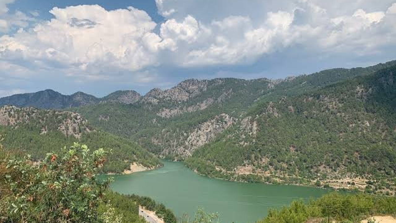

Nestled in the deep valley of the Aksu Çayı, where the Taurus Mountains meet the borders of Bucak district in Burdur and Antalya province, lies Karacaören Dam – a vast, shimmering expanse of water. In the early morning, the lake's surface is perfectly still, reflecting the majestic red pines from the opposite slopes. Apart from a few patient anglers, the area remains wonderfully tranquil. A portion of this water flows from the north, originating in Kovada Lake National Park in Isparta. The connection between these two stunning destinations is both geographical and practical: it's entirely possible to explore both the dam's shores and the national park's forest trails within the same weekend. This comprehensive guide will help you navigate this incredible route, covering transport, ideal seasons, accommodation, and hiking opportunities.
Quick Facts
| Topic | Information |
|---|---|
| Location | Aksu Çayı valley, border of Burdur (Bucak) and Antalya; Kovada Lake in Isparta (Eğirdir-Sütçüler) |
| Highlights | Dam lake shore, Kovada Lake National Park, Yazılı Kanyon area |
| Distance | Karacaören Dam lake is approx. 35 km from Bucak town center; Kovada Lake is approx. 24 km from Eğirdir |
| Best time to visit | April-June and September-October |
| Transport | By road via Antalya or Isparta; private car is the most practical solution |
| Duration | Full day for the dam shore, two comfortable days for both destinations |
| Activities | Nature walks, sailing and canoeing, angling, photo safaris, bird watching |
Things to Do at Karacaören Dam: Sights to See
The region's itinerary revolves around two main attractions and several neighboring points of interest. The dam lake offers a vast, open expanse of water, while Kovada Lake National Park provides a shaded, forested environment perfect for hiking. Along the valley connecting them, you'll discover remnants of Pisidian-era settlements and breathtaking canyon views.
Karacaören Dam Lake Shore
Karacaören Dam is a tiered dam system built on the Aksu Çayı to generate energy and provide irrigation for the Antalya plains. Because the river is held by two separate bodies in the same valley, the names Karacaören I and Karacaören II are often used together in the region. This river, known as Kestros in ancient times, was the main waterway feeding the plains around Perge in the lower basin. Thus, the lake is not just an engineering marvel but also a vital part of the region's water history.
The lake takes its name from the village of Karacaören, located in the Bucak district. There's approximately a 35-kilometer drive from the district center to the lake shore. When using navigation apps, searching for the specific village name rather than a broad regional name will make it easier to find the turn-off to the shore.
The main attraction here is the scenery itself: steep slopes, a blanket of red pines, and a waterline that rises and falls with the seasons. Some parts of the valley are home to protected sweetgum trees, adding a unique texture to the area, distinct from the typical Taurus coastal vegetation. Angling is popular in the lake's shallow coves, and on weekends, families often gather for picnics. Designated picnic areas around Karacaören I and II dams are located along this stretch. When water levels drop, the shoreline recedes, creating a muddy strip, so driving right up to the water's edge isn't always advisable.
Practical tip: Some roads leading to the shore are unpaved and can become slippery after rain, so a vehicle with higher ground clearance will make your journey easier. For timing, the early morning hours and late afternoon near sunset are ideal for both photography and calm, windless water surfaces. Shaded, organized areas are limited, so staying for extended periods during summer afternoons can be tiring.
Water Sports and Fishing at the Dam Lake
The Ministry of Culture and Tourism promotes Karacaören Dam for activities such as sailing, canoeing, surfing, photo safaris, dam tours, angling, swimming, and nature walks. This means the lake is not just a scenic view from the shore but also an active playground on the water. The consistent winds blowing through the valley create an ideal environment for sailing and canoeing.
Numerous fish farms operate on the lake, supporting professional fishing, while amateur anglers can find plenty of free spots along the shore. Those considering swimming should be aware that the dam lake's depth increases rapidly away from the shore, the bottom structure is variable, and currents may be present. If you're looking for a similar dam lake experience closer to Antalya, check out our Green Canyon travel guide.
Kovada Lake National Park
Kovada Lake is located in Isparta's Eğirdir district and forms the heart of a 6,534-hectare protected area, declared a national park in 1970. The park's boundaries stretch between Eğirdir and Sütçüler districts, and in 1992, it gained first-degree natural site status. The lake is approximately 24 kilometers from Eğirdir town center. It's fed from the north by the Kovada Canal, a roughly 22-kilometer channel carrying excess water from Eğirdir Lake. The water then passes through the Kovada I and Kovada II hydroelectric power plants before joining the Aksu Çayı and eventually reaching Karacaören Dam Lake in the lower basin. This interconnected water system is precisely why these two destinations make for a perfect combined itinerary.
Within the park, you'll find scenic viewpoints along the lake shore, day-use areas within the forest, and a park road accessible by vehicle. The dominant vegetation of red pines and junipers comes alive with blooming herbaceous plants in spring. The lake's shallow sections are excellent spots for observing water birds. The dense forest canopy provides a cooler environment throughout the day compared to the open lake shore.
Practical tip: There's a control point at the national park entrance, and visits are generally limited to daylight hours. Rules regarding camping, lighting fires, and parking are subject to park regulations; it's essential to check the current guidelines on the information boards at the entrance. For optimal timing, late April to early June and the month of September offer pleasant conditions.
Hiking Around the Lake and St. Paul Trail
Kovada Lake National Park lies along the St. Paul Trail, a long-distance hiking route extending from the ancient cities on the Antalya coast towards Yalvaç. Two branches, starting from Perge and Aspendos, converge southeast of Kovada Lake, with the route culminating at Pisidia Antiokheia in Yalvaç. The entire 500-kilometer trail is recommended to take 27 days. For those interested in comparing Turkey's marked long-distance paths, our Lycian Way guide offers further insights. While tackling the entire route takes weeks, shorter sections around the park can be enjoyed as day trips. The trail is marked with red and white blazes; it's advisable to download an offline map as forest paths can sometimes diverge.
Activities here include walking along the flat trail that follows the lake shore, ascending side trails to reach panoramic lake views, and taking a refreshing break in the shade of the forest. If you're looking for a pre-planned, hiking-focused adventure, explore our nature and adventure tours options.
Practical tip: Cell phone reception can be spotty within the valley; walking in a group and pre-determining a return time are important for safety. As there are no regular water sources along the trail, make sure to carry sufficient drinking water with you.
Towards Yazılı Kanyon Nature Park
For those heading east, Yazılı Kanyon Nature Park, approximately 20 kilometers from Sütçüler town center, offers a compelling alternative. Located within the borders of Çandır village and declared a nature park in 1989, this area spans about 600 hectares, with canyon walls reaching heights of 100 to 400 meters in places. It gets its name ("Written Canyon") from an ancient inscription carved into the rock face within the canyon, believed to contain lines about the free human, attributed to the Stoic philosopher Epictetus. The area also preserves traces of an ancient route known locally as the "King's Road," extending from Perge via Adada to Yalvaç.
The trail at the canyon floor ascends, following the streambed. Even in summer, this section remains cool, making it a comfortable path for midday walks. Shoe choice is important, as the stones can become slippery when wet, causing slips during stream crossings.
Ancient Cities of the Aksu Valley
The valley is surrounded by the mountainous cities of the Pisidia region. On the Bucak side, Kremna, near Çamlık village, is built on a steep plateau overlooking the Aksu valley and was one of the Roman colony cities established in Pisidia. Its city walls, forum area, basilica, and theater ruins are still visible. Statues of gods and goddesses unearthed during excavations in the early 1970s are now displayed at the Burdur Archaeology Museum, so a visit to the museum before or after seeing the site offers a more complete historical experience. To the northeast, Adada, located within the borders of Sağrak village approximately 10 kilometers from Sütçüler town center, is known for its imperial temples, forum structure, and well-preserved sections of a stone-paved ancient road, which is also part of the St. Paul Trail route.
These ancient cities offer a different pace than more crowded archaeological sites; you'll often share the space with just a few other visitors. For those looking to combine ancient cities into a structured itinerary, explore our cultural tours options. Shade and facilities are limited at both sites, so a hat, water, and closed-toe shoes are essential.
Connection to Eğirdir Lake
To the north of Kovada lies Eğirdir Lake, one of Turkey's largest freshwater lakes. Yeşilada, an island connected to the town center, with its charming lakeside settlement, can serve as a perfect accommodation hub for your route. The apple orchards along the lake shore, fishing piers, and the lively promenade that comes alive in the evening provide an ideal setting to end your day. Since the road to Kovada Lake also branches off from this town center, it naturally becomes a convenient starting point for your itinerary.
How to Get There
The main artery for reaching this region is the highway connecting Antalya and Isparta. Since the distance between the two main stops isn't short, it's essential to plan your day in advance.
- If you're coming from Antalya, take the D-685 highway towards Isparta and follow signs for Bucak. The turn-offs leading down to the dam lake are along this route.
- If you're coming from Isparta or Eğirdir, first visit Kovada Lake National Park, then continue south into the Aksu valley.
- Those using public transport should aim for the bus terminals in Antalya, Isparta, or Eğirdir. Connections from these town centers to the lake shore and park entrance are infrequent, so completing the final leg by taxi or rental car is a common solution.
- For air travelers, Antalya Airport and Isparta Süleyman Demirel Airport serve as two separate gateways. Arranging car rental at the airport will save you time.
Seeing the main stages of the route by distance will help you plan your day effectively.
| Stage | Approximate Distance | Notes |
|---|---|---|
| Antalya - Bucak | 87 km | Ascent via Çubuk Beli pass, approx. 1.5 hours |
| Bucak - Karacaören Dam Lake | 35 km | Final section includes local roads and unpaved turn-offs |
| Isparta - Eğirdir | 34 km | Divided highway, approx. half an hour |
| Eğirdir - Kovada Lake National Park | 24 km | Narrow and winding forest road, not recommended in the dark |
| Sütçüler - Yazılı Kanyon Nature Park | 20 km | Canyon entrance is within Çandır village limits |
Arriving from Antalya
The journey from Antalya to Bucak is approximately 87 kilometers, traversing the Taurus Mountains via the Çubuk Beli pass, which stands at an elevation of 925 meters. Under normal conditions, the drive takes about an hour and a half. During winter months, fog and ice can be encountered in this section. While it's possible to approach the southern shore of the dam lake from Antalya, signage is limited. For more accurate navigation, searching for the nearest settlement to the shore, such as Karacaören village, rather than a broad regional name, will yield better results.
Arriving from Isparta and Eğirdir
The distance between Isparta and Eğirdir is approximately 34 kilometers, taking about half an hour by car. From Eğirdir, the road heading south towards Sütçüler reaches the entrance of Kovada Lake National Park after about 24 kilometers. Along this route, you'll be treated to views of apple orchards and the lake. After exiting the park, you can follow the valley down to the Aksu Çayı and reach the dam lake. As the road is narrow and winding, driving in the dark is not recommended.
Sample Weekend Itinerary
For those who wish to experience both destinations without feeling rushed, a two-day itinerary works perfectly.
- Day One Morning: Depart from Eğirdir, enter Kovada Lake National Park, and enjoy a short walk along the lake shore trail.
- Day One Afternoon: Head towards Sütçüler and explore Yazılı Kanyon Nature Park, following the streambed. Spend the evening in Eğirdir or Sütçüler.
- Day Two Morning: Follow the valley south and descend to the shore of Karacaören Dam Lake. The morning light offers ideal conditions for photography.
- Day Two Midday: Drive towards Bucak to visit the ruins of Kremna, taking in the panoramic valley views from the plateau.
- Day Two Evening: On your return journey towards Antalya, take a break along the route and complete your drive in daylight.
When to Visit? Seasonal Comparison
| Period | Advantage | Note |
|---|---|---|
| Spring (April-June) | High water levels, vibrant vegetation | Dirt roads can soften after rain |
| Summer (July-August) | Long daylight hours, ample hiking window | Midday heat can be challenging, shade is limited |
| Autumn (September-October) | Tranquil environment, mild weather, clear views | Days shorten, plan return times earlier |
| Winter (November-March) | Quiet area, unique atmosphere | Fog and icing can occur in higher elevations |
The rose harvest around Isparta typically falls between late May and early June. During this period, the fragrant gardens add a special charm to the northern leg of the route. In mid-summer, planning hikes for early mornings or late afternoons ensures a more comfortable experience.
Dining and Accommodation Areas
You won't find large chain hotels in this region; accommodation is generally categorized into two types. Along the dam lake shore, there are bungalow-style lodging units and dining facilities, but capacity is limited, and service arrangements may change outside of peak season. The second category includes guesthouses, mountain lodges, and city hotels scattered across the surrounding districts. Therefore, your choice should depend more on which end of the route you plan to start from, rather than solely on the view.
| Region | What it offers | Best for |
|---|---|---|
| Karacaören Dam Lake Shore | Bungalow-style units, lakeside dining facilities | Those who want to stay right by the water |
| Eğirdir and Yeşilada | Lakeside guesthouses, fish-focused menus | Travelers starting their route from the north |
| Sütçüler and surrounding villages | Small-scale guesthouses and mountain lodges | Plans focused on canyons and hiking |
| Bucak and Aksu valley | Accommodation along the highway, local meat dishes | Visitors arriving from Antalya |
| Isparta city center | City accommodation, extended service hours | Those using airport connections |
Local Cuisine
Around Isparta, rose products and apples are prominent, while Eğirdir is known for its lake fish. Along the Burdur route, meat dishes, particularly şiş köfte (skewered meatballs), are a local specialty. Village breakfasts along the road are typically served early and cleared by midday, so it's a good idea to schedule your breakfast stop at the beginning of your route. For those who wish to make local cuisine a central part of their travel program, explore our gastronomy and event tours options.
Day-Use Areas and Camping
There are day-use areas along the dam shore and within the forest, but the infrastructure standard varies. Within national park boundaries, rules regarding accommodation, fires, and overnight stays are determined by park management; setting up a tent without first inquiring at the entrance could lead to issues. For those arriving with caravans, the narrow and steep sections of the valley roads can make maneuvering longer vehicles challenging.
Practical Tips Before You Go
- Fill up your fuel tank in the town center; gas stations become scarce within the valley.
- Bring drinking water, a hat, and non-slip hiking shoes.
- Download an offline map, as phone signal can be weak on forest roads.
- Do not leave your trash in the area, and refrain from lighting fires within national park boundaries.
- Before driving down to the water's edge, check the firmness of the ground.
- If you plan to sail, canoe, or surf, bring your own equipment; regular rental points may not be available on the shore.
- Book accommodation in advance during holidays and long weekends.
- Plan your return journey to start before sunset.
How Many Days Should You Allocate for This Route?
Karacaören Dam and Kovada Lake National Park showcase two distinct faces of the same water basin: one an open, expansive lake surface, the other a dense, shaded forest area. For those focusing solely on the dam shore, a full day is sufficient. If you wish to combine both destinations and perhaps add a third point like Yazılı Kanyon or Kremna, a two-day itinerary is recommended. Extending your trip to three days will comfortably allow you to explore the Eğirdir area and Adada as well. For travelers who prefer to plan their regional tour with pre-designed programs, you can start by browsing our complete tour programs.
Frequently Asked Questions 7
Where is Karacaören Dam located?
Karacaören Dam is situated on the Aksu Çayı, in the valley where Burdur's Bucak district meets the provincial border of Antalya. It is approached via the highway from Antalya towards Isparta, with turn-offs leading down to the lake shore along this route.
What activities can be done at Karacaören Dam?
Official promotions list sailing, canoeing, surfing, photo safaris, dam tours, angling, swimming, and nature walks as activities for the lake. Additionally, there are picnic areas along the shore, scenic views, and bird watching opportunities. Nearby ancient cities and Kovada Lake National Park offer further attractions that can be combined into the same day's itinerary.
How far is Karacaören Dam from Bucak?
The dam lake is approximately 35 kilometers from Bucak town center. The journey from Antalya city center to Bucak is about 87 kilometers; combining both stages, the drive typically takes a little over two hours under normal conditions.
Where is Karacaören Pond (Göleti)?
The term "Karacaören Pond" (Karacaören Göleti) often refers to the dam lake on the Aksu Çayı. Since there are other small ponds with the same name in different provinces across Turkey, when getting directions, it's important to specify the Aksu valley on the border of Burdur and Antalya.
Which administrative division does Karacaören belong to?
The shoreline of the dam lake is shared between Burdur and Antalya provinces. The closest district center to the dam body is Bucak in Burdur. Kovada Lake National Park, on the other hand, is administratively part of Eğirdir district in Isparta.
How are Kovada Lake and Karacaören Dam connected?
Excess water from Eğirdir Lake is channeled into Kovada Lake. From there, the water passes through hydroelectric power plants before joining the Aksu Çayı, which then feeds the dam lake in the lower basin. These two points are different links in the same interconnected water system.
Is there accommodation around Karacaören Dam?
Bungalow-style accommodation units and dining facilities can be found along the lake shore, but capacity is limited. For those seeking broader options, guesthouses, mountain lodges, and city hotels in the Eğirdir, Sütçüler, and Bucak areas are available. During peak seasons, it's advisable to book in advance.