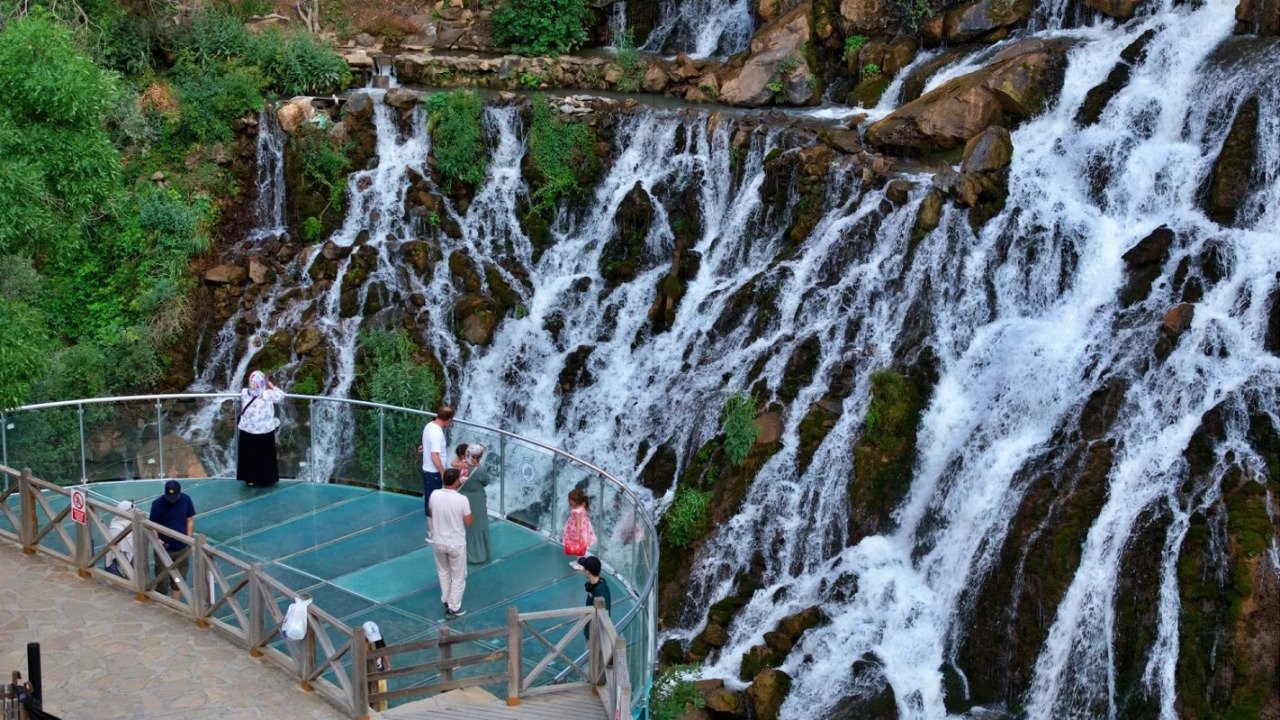

In the Şiran district, located southwest of Gümüşhane, around forty springs emerge from cracks in the mountain slope, converging before cascading down a steep cliff. Tomara Waterfall offers a serene encounter with water in the heart of the Eastern Black Sea Region. For travelers accustomed to the misty plateaus of the coast, this offers a different kind of spectacle; this valley, approximately 110 kilometers from the provincial center, is like a cool oasis amidst the dry ridges of the Kelkit basin. This guide brings together information on the waterfall's formation, its glass observation terrace, the walking paths in the nature park, how the water flow changes throughout the months, and directions starting from Şiran town center.
Where is Tomara Waterfall? A Quick Overview
Tomara Waterfall is located within the borders of Seydibaba village, part of Gümüşhane's Şiran district. It is approximately 23 kilometers from Şiran town center and about 110 kilometers from Gümüşhane city center; the route is established from Şiran, not the provincial center. The waters of around 40 springs, locally known as "kırk gözeler" (forty springs), cascade over a cliff face, varying between 14 and 22 meters in height depending on the section, spreading across approximately 35 meters in width. The surrounding area has held Nature Park status since 2011, with the protected section covering about 70 decares. The first stop for visitors is the glass observation terrace, built opposite the waterfall.
Quick Facts
| Topic | Information |
|---|---|
| Location | Gümüşhane, Şiran district, Seydibaba village |
| Distance | Approx. 23 km to Şiran center, approx. 110 km to Gümüşhane center |
| Highlights | Kırk gözeler springs, glass observation terrace, oak forest |
| Status | Nature Park since 2011, approx. 70 decares protected area |
| Best Time to Visit | Late May to mid-September |
| Access | Private car offers the most flexibility; local connections via Şiran |
The Waterfall's Formation and What to See in the Nature Park
From Hillside Springs to a White Curtain of Water
The waterfall's water doesn't come from a single stream, but from around 40 karstic springs emerging from cracks in the mountain slope; locals call this cluster of springs "kırk gözeler" or "forty springs." The drop height is not uniform across the face: it measures approximately 18 meters on the eastern side, 14 meters in the middle, and 22 meters on the western side; this is why various sources cite heights between 15-25 meters. The water spreads across approximately 35 meters in width, creating the impression of a white curtain. Tomara Stream, a tributary of the Kelkit River, collects this water downstream and carries it through the valley. The waterfall takes its name from the local 'kaldirik' plant, known regionally as 'tomara,' which grows in the area.
The Glass Observation Terrace
Built by the 12th Regional Directorate of Nature Conservation and National Parks, the glass observation terrace offers a unique vantage point to witness the cascade from both above and head-on. Its transparent floor also allows you to see the rocky riverbed below.
Walking Paths in the Oak Forest
The park's surroundings are covered with centuries-old oak trees; wooden walking paths connect one end of the area to the other and lead to picnic spots shaded by the trees. The routes are easy, making them perfect for families with children. For those looking to explore the region's walking routes with a guided program, you can check out our nature and adventure tours options.
Seasonal Water Flow Calendar
The waterfall's appearance is largely determined by its water flow.
| Period | Water Flow | Notes |
|---|---|---|
| April-May | Highest flow due to snowmelt | Paths can be slippery |
| June-August | Strong flow, prominent foam | Weekends get busier |
| September-October | Flow decreases, foliage turns golden | Calm, serene for photography |
| November-March | Low flow, possibility of snow | Mountain roads may close |
How to Get to Tomara Waterfall via Şiran
The town of Şiran is the central hub for access.
- Base yourself in Şiran town center or plan your route through here.
- Upon leaving the town, follow the signs for Seydibaba village and continue on the connecting road for approximately 23 kilometers.
- In the final section, the road narrows and becomes winding; set your navigation to the village name rather than the waterfall itself.
- After parking your vehicle, walk from the nature park entrance down to the terrace and waterfall area.
Airport and Bus Connections
The closest airports are Erzincan and Trabzon; from both, onward travel is by road. Those arriving by bus should aim for Şiran bus station and then take a local vehicle or taxi to the waterfall. Public transport services are limited, so inquire about return times in advance.
Extending Your Itinerary: Gümüşhane's Other Gems
| Stop | District | From City Center | Suggested Time |
|---|---|---|---|
| Tomara Waterfall | Şiran | ~110 km | Half day |
| Karaca Cave | Torul, Cebeli village | ~17 km | 1-2 hours |
| Kov Castle | Merkez, Esenyurt village | ~21 km | 1 hour |
| Limni Lake | Torul, Zigana | ~45 km | 2-3 hours |
Karaca Cave
Karaca Cave, located around Cebeli village in Torul, is approximately 17 kilometers from the city center and sits at an altitude of 1550 meters. Discovered in 1983 and opened to visitors in 1996, this karstic formation is renowned for its stalactites, stalagmites, and columns. Since Şiran and Torul are in opposite directions, trying to fit both into a single day would be tiring.
Kov Castle
Kov Castle rises on a steep rock face along the Gümüşhane-Erzincan highway, 21 kilometers from the city center, in Esenyurt (Kov) village, part of the Merkez district. It is believed to have been built around 1361 during the reign of Alexios III of Trabzon and was restored in 2007. It is known for its rock-carved steps and tales of a secret water passage. The climb is short but steep; morning hours are ideal. As the same highway is used when heading to Şiran, the castle can be added to your Tomara day, rather than a separate Torul day. For those wishing to add historical layers to their itinerary, you can choose from our historical city tours.
Limni Lake Nature Park
Located around Zigana, amidst high-altitude pine forests, Limni Lake Nature Park is perfect for relaxation with its tranquil lake views and wooden walking platforms; it's an ideal roadside stop for those using the Zigana pass.
Planning Your Visit and Budget Tips
As Tomara Waterfall is within a nature park, entry procedures and parking arrangements may vary seasonally. Karaca Cave, on the other hand, is operated by the Gümüşhane Provincial Special Administration; since it's not affiliated with the Ministry of Culture and Tourism, the Museum Pass (Müzekart) is not valid here, and the cave is generally open from 08:30 to 17:30. Confirm current fees from the administration's announcements before you set off. The main budget items will be transportation and accommodation.
Accommodation and Dining Areas
There are two logical bases for accommodation. Şiran town center is practical due to its proximity to the waterfall, offering modest guesthouses and small hotels. Gümüşhane city center provides a wider range of facilities and is a balanced base for a second day covering stops towards Torul. Those seeking a night immersed in nature can look into mountain lodges around Zigana.
For dining, local 'siron' (a type of pastry) and Gümüşhane bread baked in a wood-fired oven are highlights. Businesses around the park are limited; day-trippers should bring snacks and water. On your way back, the central bazaar is a convenient stop for 'köme' and 'pestil' (local fruit pulp desserts); for a breakdown of regional flavors, you can check our article on Black Sea cuisine delights, and for similar themed programs, visit our gastronomy and event tours page.
Tips Before You Go
- Bring protective cases for your phone and camera against water spray.
- Even in summer, the area around the waterfall is cool; bring a light top layer.
- Wooden platforms can become slippery when damp, so opt for non-slip footwear.
- Gas stations are scarce on the village roads; fill up your tank in Şiran.
- Parking can fill up on weekends and holidays, so aim for early hours.
How Many Days to Spend Around Şiran?
Half a day is sufficient for the waterfall and nature park; those who wish to explore the walking paths thoroughly might allocate a full day. If you plan to see Gümüşhane's other attractions, a two-day plan offers a relaxed pace: Day one for Kov Castle via the Erzincan highway, then Şiran and Tomara; Day two for Karaca Cave and Limni Lake towards Torul. For those looking to extend their itinerary to neighboring provinces, you can check our Black Sea tourism guide; for a culture-focused plan, cultural tours are suitable.
Frequently Asked Questions 8
Where is Tomara Waterfall in Gümüşhane?
It is located within the borders of Seydibaba village, part of the Şiran district. It is approximately 23 kilometers from Şiran town center and about 110 kilometers from Gümüşhane city center.
When is the best time to visit Tomara Waterfall?
The water flow is highest in April and May due to melting snow. For travel comfort, the period between June and September, when the roads are clear, is ideal.
Where is Karaca Cave in Gümüşhane?
It is located around Cebeli village, part of the Torul district, approximately 17 kilometers from the city center. It is in the opposite direction from Şiran.
What is the history of Karaca Cave?
The cave was discovered in 1983 and opened to visitors in 1996 after development work. This karst formation, at an altitude of 1550 meters, is known for its stalactite, stalagmite, and column formations.
How much is the entrance fee for Karaca Cave?
The cave is open to visitors for a fee, and since it is operated by the Gümüşhane Provincial Special Administration, the Museum Pass (Müzekart) is not valid. As tariffs are updated periodically, it is advisable to confirm the current fees from the administration's announcements before you set off.
Where are the Santa Ruins in Gümüşhane?
They are located on a forested hillside around Dumanlı village, part of the Central district, approximately 72 kilometers from the city center. Since they are in the opposite direction from Şiran, they require a separate day to visit.
Who lived in the Santa Ruins?
It is believed that an Orthodox Greek population, engaged in mining and silver craftsmanship, lived in the stone settlement consisting of seven neighborhoods, and the settlement was evacuated during the 1923 population exchange.
What are the famous places in Gümüşhane?
Prominent stops include Tomara Waterfall, Karaca Cave, Limni Lake Nature Park, Kov Castle, the Zigana region, and the Santa Ruins. On the culinary side, 'köme' and 'pestil' are well-known regional products.