
Planning a visit to Eyüpsultan isn't just about a list of places; it's about following three distinct routes. The district's walkable charm unfolds along Cami-i Kebir Street, extending from the main square; Defterdar and Zal Paşa streets, running parallel to the Golden Horn; and the stepped hill path that winds through ancient cemeteries up to the Pierre Loti ridge. By walking these three routes in sequence, you'll avoid climbing the same incline twice and experience the tombs and madrasahs exactly as they open onto their respective streets. Below, we detail what you'll find on each route, distances measured from Eyüpsultan Pier, and where the terrain changes.
Quick Facts for Your Visit
| Topic | Information |
|---|---|
| Location | Istanbul, Eyüpsultan district; northern end of the Golden Horn |
| Walking Routes | Cami-i Kebir Street, Defterdar and Zal Paşa streets, hill path through the cemeteries |
| Starting Point | Eyüpsultan Pier and the main square in front of it |
| Route Length | Approximately 1.3 kilometers, 19 minutes of pure walking |
| Including Stops | 2.5 - 3 hours |
| Terrain | Flat square, cobblestones, stepped stone incline |
| Rail Connection | T5 Tram line's Eyüpsultan Teleferik station |
| Hill Ascent Alternative | TF2 Eyüp-Pierre Loti cable car line; 0.42 kilometers, 3.25 minutes one-way |
| Entrance Fee Note | No fees for mosque or tomb entry |
What to See in Eyüpsultan's Historic Streets
The sights in Eyüpsultan's streets unfold in three layers: the central mosque and tomb complex facing the main square, the structures built by viziers and valide sultans lining the streets, and the ancient cemeteries (hazireler) that encircle all these buildings. What makes this district unique is that these structures aren't confined to a museum courtyard; they stand on street facades where daily life still thrives. As you walk, you'll pass door thresholds, ornate fountain grilles, and madrasah courtyard walls in a continuous flow.
| Structure | Built by, when | Location | Current Status |
|---|---|---|---|
| Tomb of Ebu Eyyub el-Ensari | Fatih Sultan Mehmed, 1454-55 | Main square and courtyard | Open to visitors |
| Eyüp Sultan Mosque | Original structure 1458; current building opened October 24, 1800 | Main square axis | Open for worship and visitors |
| Sokollu Mehmed Paşa Tomb and Madrasah | Mimar Sinan, 976 (1568) | Cami-i Kebir Street | Tomb open to visitors since May 1993 |
| Zal Mahmut Paşa Külliyesi | Mimar Sinan, 985 (1577) | Between Defterdar and Zal Paşa streets | Mosque open for worship, other units used for cultural programs |
| Mihrişah Valide Sultan Imaret | Construction began 1793, completed 1796 | Defterdar axis, descending to the shore | Operates as a soup kitchen by the General Directorate of Foundations |
Cami-i Kebir Street: A Row of Tombs and Madrasahs
Branching off from the main square, Cami-i Kebir Street is the district's most densely stone-faced thoroughfare. According to Eyüpsultan Municipality records, the Sokollu Mehmed Paşa Tomb stands on this street, opposite the Siyavuş Paşa Tomb. Mimar Sinan's structure, dating back to 976 (1568), is octagonal externally and sixteen-sided internally, clad in cut stone. The madrasah, according to the same records, is directly opposite the tomb's entrance, with its courtyard gate to the tomb's left. This detail is useful as you walk the street: a tomb on one side, a madrasah opposite, and the street itself between them. The building was damaged in the 1894 earthquake, and its library and fountain, along with its water channels, were repaired in 1895. The tomb was opened to visitors in May 1993.
For those who wish to explore this axis and the cemetery walls facing the street with expert commentary, you can check the programs under Istanbul cultural tours. The language of the stone inscriptions can be challenging to decipher without assistance.
Defterdar and Zal Paşa Streets: A Külliye Opening to Two Thoroughfares
As you head from the main square towards the Golden Horn, the urban fabric shifts, and the streets settle into a calmer neighborhood rhythm. The Zal Mahmut Paşa Külliyesi serves as the anchor of this section. According to municipal records, Mimar Sinan completed the structure in 985 (1577), commissioned by Zal Mahmud Paşa, the sword-bearer of Süleyman the Magnificent, and his wife Şah Sultan; both are interred in the same tomb. The alternating stone and brick masonry, the mosque's two-tiered body, and the fountain in the courtyard dated 998 (1589) are details worth observing closely.
The külliye's relationship with the street is one of the most insightful aspects of this walk: the complex sits between Defterdar Street and Zal Paşa Street, with entrances opening onto both. This means you can enter from either direction, though the facade you first encounter will differ. The minaret was destroyed in the 1894 earthquake and subsequently rebuilt, with extensive foundation repairs carried out between 1955 and 1963.
Mihrişah Valide Sultan Imaret: A Foundation Still Serving the Community
Located on the axis descending to the shore, this imaret is a structure on our route that continues its historical function to this day. Construction began on June 6, 1793, and the building was completed by the end of 1796. Its portico, with its rows of domes, casts a long shadow over the street. According to the General Directorate of Foundations, the imaret currently operates as a soup kitchen, serving up to 3,500 people daily. Even if you don't enter, you'll notice the queue forming on the street around lunchtime and the sounds emanating from the kitchen. Witnessing a foundation building operate continuously for over two centuries tells a more profound story than simply admiring its stone facade.
Hazireler (Cemeteries): An Open-Air Stone Archive Along the Streets
The true essence that distinguishes Eyüpsultan from other neighborhood walks is its hazireler, or historic cemeteries. The area ascending the hillside from the central mosque and tomb complex is formed by overlapping small, walled cemetery courtyards. In many places, your path will weave directly through these courtyards. The difference between the turban and fez motifs on the stone headstones indicates changes in eras, while the calligraphic style of the inscriptions points to the period when the stone was erected. While deciphering these requires expertise, even for the amateur observer, one rule helps: look at the headstone's cap, its orientation, and the plant motifs on it—all three together will give you an idea of who the stone was erected for. Parts of the hazire areas may occasionally be cordoned off for conservation work; checking the information sign at the gate will prevent a wasted detour.


How Long Does the Hill Path Take, and How Steep Is the Climb?
The sequence of stops, starting from Eyüpsultan Pier and ascending through the hazireler to the Pierre Loti ridge, is approximately 1.3 kilometers. When the durations in the table below are added up, the net walking time is 19 minutes. Including detours into side streets and the return journey, the total walk extends to 2 to 2.5 kilometers. With time spent at stops, the entire program will take 2.5 to 3 hours. The distances in the table are approximate values measured along the route from the pier, not from the cable car's lower station.
| Stop Order | Approximate Distance to Next Stop | Walking Time | Terrain and Incline |
|---|---|---|---|
| 1. Eyüpsultan Pier and Shoreline | 200 meters | 3 minutes | Flat shoreline walk |
| 2. Main Square and Porticoed Courtyard | 150 meters | 2 minutes | Flat stone courtyard |
| 3. Around the Tomb of Ebu Eyyub el-Ensari | 250 meters | 3 minutes | Flat marble corridor |
| 4. Cami-i Kebir Street and Sokollu Complex | 300 meters | 4 minutes | Cobblestones, nearly flat |
| 5. Cemetery Path and Cypress-Lined Ascent | 400 meters | 7 minutes | Stone-paved steep incline |
| 6. Pierre Loti Ridge and Observation Deck | Route ends here | Total 19 minutes | Flat observation deck |
Where the Terrain Changes on the Ascent
The incline isn't consistent from start to finish. For the first four stops, the ground is level, and the walk is much like any other street stroll. The real climb begins at the fifth stage, on the stone-paved path that winds through the cemeteries. In this section, the step heights are irregular, and some stones have become smooth and polished over time. While this isn't an issue in dry weather, it requires careful footing after rain. A pair of sturdy, flat-soled shoes will make a much bigger difference on this 400-meter stretch than on the rest of the walk.
Alternatives for Those Challenged by Steps
The stepped path is not suitable for strollers or wheelchairs. The lower cable car station at the shore level provides an alternative for this need; the line's length and duration details are provided in the Quick Facts table above. Since the cable car may not operate continuously throughout the day, if you plan to make it a central part of your itinerary, confirm the day's operating status from the operator's announcements. For those who enjoy walking, a practical approach is to ascend the hill with fresh legs, taking time to read the cemetery stones during the climb, and then decide on your descent route once you reach the top. This way, pausing to catch your breath in front of the stones becomes part of the experience, not a loss of time.
Which End Should You Start Your Walk From?
Starting the route from the shore end works in your favor regarding the incline, as you'll tackle the elevation difference between the square level and the hilltop level once, and with fresh legs. A common mistake for those arriving by land is searching for the stop name: the T5 tram line stations in this area are named Feshane, Eyüpsultan Teleferik, and Eyüpsultan Devlet Hastanesi, so simply looking for "Eyüpsultan" on the map won't yield results. The closest disembarkation point to the main square and the Cami-i Kebir axis is the Eyüpsultan Teleferik station.
For those preferring the sea leg, the northern terminus of the ferry services operating on the Golden Horn ends directly in front of this square. The walk from the pier to the square takes just a few minutes, and the route begins exactly as described in the first row of our tables. Since the T5 line follows the same shoreline as the pier, extending south along the Golden Horn, those wishing to divide their day between two districts can combine this walk with the coastal and uphill sequence found in our Balat travel guide. If you want to make the water an integral part of your itinerary, you can dedicate the second half of your day to ferry trips along the Golden Horn and Bosphorus.


Best Seasons and Times to Explore These Streets
The early morning hours offer the most comfortable window for this route, providing both shade and tranquility. The main square axis begins to fill up towards noon. On Friday afternoons and religious holidays, walking around the square noticeably slows down; shifting these hours to the cemetery (hazire) section helps maintain a smoother flow.
| Period | Pavement and Incline Condition | Impact on Street Atmosphere |
|---|---|---|
| March-May | Steps dry, incline cool | Inscriptions more legible in slanted light |
| June-August | Little shade on the main square axis | Early hours are both cool and less crowded |
| September-November | Fallen leaves cover the steps | Light softens under plane and cypress trees |
| December-February | Wet stones are slippery, pace slows | Darkness falls early, so prioritize the hilltop section |
Crafts and Culinary Delights Along the Streets
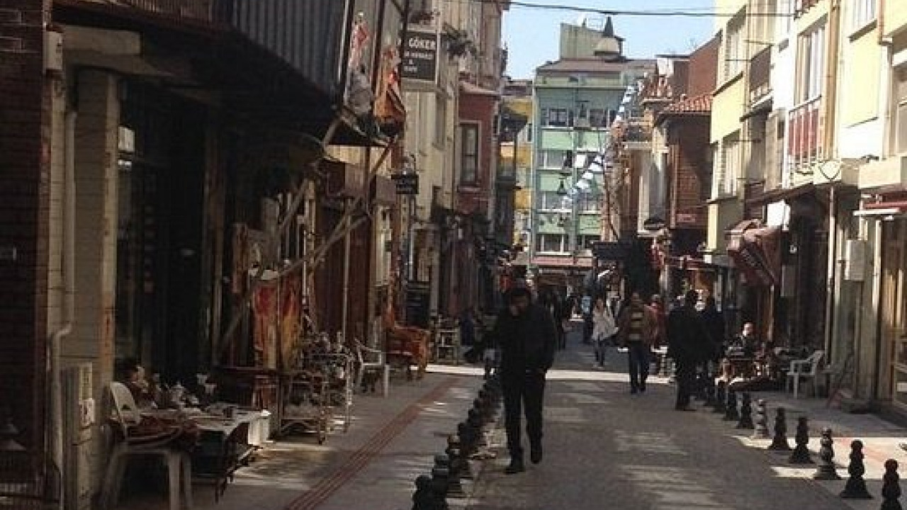
The row of shops between the main square and Cami-i Kebir Street forms a second layer of the district's itinerary. The stalls here are less about generic tourist souvenirs and more about the district's own production traditions. If you need a quick break during your walk, the dessert and sherbet vendors are the closest options to the square. For a more substantial lunch after the uphill climb, a traditional stew (güveç) cooked in an earthenware pot would be a perfect choice.
Coppersmiths, Toy Makers, and Calligraphy Supplies
Workshops producing hammered copper ewers and trays announce their presence with the rhythmic sound of hammers. These shops are worth a stop, not just for shopping, but to witness traditional metal craftsmanship in action. The district's toy-making is also a craft in itself: wooden cradles, horses, and tambourines, made with natural dyes, are often cited in discussions about the city's intangible cultural heritage. Along the street, you'll find second-hand bookshops and traditional art stores offering calligraphy materials such as ebru paper, reed pens, and ink. For those who prefer a guided experience, Istanbul tour options include half-day itineraries that cover this fascinating area.
Building Your Street Route Step-by-Step
The following sequence is designed to tackle the incline once and minimize the risk of encountering closed doors at the end of your visit.
- Start from the Shore: Exit from the pier or Eyüpsultan Teleferik station and follow the shoreline to the main square.
- Enter the Courtyard: Take a short stroll around the plane tree and ablution fountain in the porticoed courtyard; observe the flow of the crowd here.
- Pass the Tomb Complex: Walk slowly through the corridor around the Tomb of Ebu Eyyub el-Ensari. If visitor traffic is heavy, circle outside and return later.
- Turn onto Cami-i Kebir Axis: See the Sokollu Mehmed Paşa Tomb and its madrasah opposite, appreciating both sides of the street together.
- Extend towards Defterdar: Enter the Zal Mahmut Paşa Külliyesi from one of its two streets, and after seeing the courtyard and fountain, exit through the other gate.
- Enter the Cemetery Path: Transition to the cypress-lined path and ascend, reading the stone headstones as you go. Take breaks on the step landings.
- Finish at the Ridge: Once you reach the Pierre Loti level, sit down, catch your breath, and decide which path you'll take for your descent.
Good to Know Before You Walk
This route is short but rich in layers of history and culture, so it's wise to prepare accordingly.
- Choose your footwear for the climb: The stone steps have irregular heights and can be slippery when wet.
- Dress respectfully for religious sites: If you plan to enter places of worship, carry clothing that covers your arms and legs. Female visitors are also expected to wear a headscarf.
- Be mindful in the cemeteries: Do not sit on the tombstones while walking through the hazireler, and when taking photos, ensure that individuals in prayer or mourning are not in your frame.
- The walk itself is free: There are no entrance fees for the mosque or tombs. If your itinerary includes a museum or a tourist boat ticket, you might see separate pricing for local and foreign visitors in the tables; confirm which pricing applies to you at the ticket counter or on the institution's official fee page.
- Carry water: Fountains are irregularly spaced along the uphill section.
- For those wishing to extend their day with a museum-focused program, our Historical Peninsula and Museums Guide provides separate details on closing days and visiting sequences.
Frequently Asked Questions 5
How long does a walk through Eyüpsultan's streets take?
The route, starting from the pier and ending at the Pierre Loti ridge, is approximately 1.3 kilometers, with a net walking time of 19 minutes. Including time spent at stops, detours into side streets, and the return journey, the entire program typically lasts between 2.5 and 3 hours.
Which tram station should visitors arriving by tram use for Eyüpsultan?
The T5 tram line stations in this area are named Feshane, Eyüpsultan Teleferik, and Eyüpsultan Devlet Hastanesi. The closest disembarkation point to the main square and the Cami-i Kebir Street axis is the Eyüpsultan Teleferik station.
What can be found on which streets in Eyüpsultan?
Cami-i Kebir Street features the Sokollu Mehmed Paşa Tomb and its madrasah opposite, as well as the Siyavuş Paşa Tomb. The Zal Mahmut Paşa Külliyesi is located between Defterdar Street and Zal Paşa Street, while the Mihrişah Valide Sultan Imaret is found on the axis descending to the shore. The main square and courtyard complex house the mosque and the Tomb of Ebu Eyyub el-Ensari.
Is the hill path accessible with strollers or wheelchairs?
The section passing through the hazireler (cemeteries) is stone-paved, steep, and stepped, making it unsuitable for these vehicles. The lower cable car station at the shore level offers an alternative for reaching the ridge.
Who built the Zal Mahmut Paşa Külliyesi?
The külliye was commissioned by Zal Mahmud Paşa, the sword-bearer of Süleyman the Magnificent, and his wife Şah Sultan. The structure is attributed to Mimar Sinan and dates back to 985 (1577). The founding couple are interred in the same tomb. The minaret was rebuilt after the 1894 earthquake, and extensive foundation repairs were carried out between 1955 and 1963.