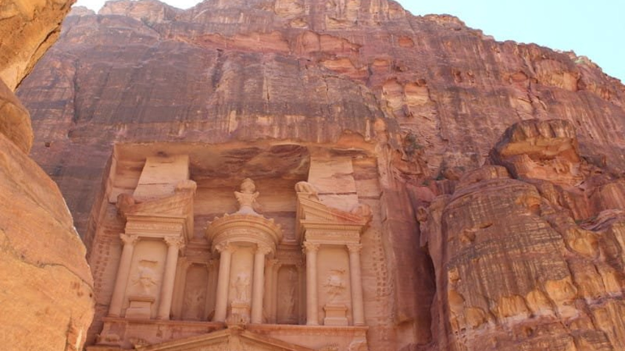

Most visitors to Petra simply marvel at the Treasury at the end of the Al-Siq and leave without ever discovering who built this city or why it was established. In reality, every carved facade is a testament to a sophisticated caravan economy and an unparalleled mastery of desert water management. This guide explores the history of the Nabataeans and Petra in chronological order: where the people came from, when they transformed the valley into a permanent settlement, what changed after the Roman annexation, and the best sequence to visit the site to truly understand its evolution. For travelers planning their trip, we have also included essential details on transport, fees, and visiting hours.
Quick Facts
| Topic | Details |
|---|---|
| Founders | The Nabataeans, an Arabic people from Northwest Arabia |
| First Appearance | 4th Century BC |
| Kingdom Era | Approx. 400 BC to 106 AD |
| End of Independence | 106 AD (Roman annexation; creation of the province of Arabia Petraea) |
| Location | Southern Jordan, Wadi Musa settlement |
| Rediscovery | 1812, by Swiss explorer Johann Ludwig Burckhardt |
| UNESCO World Heritage | December 6, 1985 |
| New Seven Wonders | 2007 |
| Entrance Fees | For overnight guests in Jordan: 1 day 50 JOD, 2 days 55 JOD, 3 days 60 JOD; Day visitors (non-overnight): 90 JOD (as of Summer 2026) |
| Visiting Hours | Summer: approx. 06:00-18:00; Winter: approx. 06:00-16:00 |
Who Were the Nabataeans and Where Did They Come From?
The Nabataeans were originally a nomadic Arabic people from Northwest Arabia, first appearing in historical records around the 4th century BC. Initially, they were a community of wanderers moving between desert oases without permanent settlements. Their decision to make Petra their home was driven by logistics rather than aesthetics: the valley sat at the crossroads of the vital caravan routes stretching from Southern Arabia to the Mediterranean, and its towering rock walls provided a natural, easily defensible fortress.
Masters of the Caravan Trade
The wealth of the Nabataeans was built on the trade of frankincense, spices, myrrh, gold, and ivory. Goods arriving from Southern Arabia were consolidated in Petra before being distributed to Mediterranean ports and northern markets. This commercial boom grew the city's population to between 10,000 and 30,000 residents. Today, the protected archaeological site spans 264 square kilometers, serving as a center where ancient Eastern traditions and Hellenistic architecture blend seamlessly.
The Golden Age of the Kingdom
The Nabataean Kingdom reached its zenith under the reign of Aretas IV (9 BC – 40 AD). Many of the iconic rock-cut facades and temples that define Petra today date back to this era. The death of the kingdom's last ruler, Rabbel II, in 106 AD provided the catalyst for Rome to bring the region under direct imperial control. Following the annexation, the administrative center of the province was moved north to Bosra.
The Timeline of Petra: From Foundation to Silence
While evidence of human presence in the valley dates back much further, Petra only gained its identity as a capital during the Nabataean era. Most sources point to the 4th century BC for its foundation, with the Nabataean peak lasting until 106 AD. Subsequently, Petra transitioned through Roman, Byzantine, and Islamic periods before eventually fading into obscurity.
City Timeline
| Period | Key Events |
|---|---|
| 4th Century BC | Nabataeans appear in records; the valley becomes a permanent settlement |
| 1st Century BC - 1st Century AD | Caravan trade peaks; monumental facades are carved into the rock |
| 106 AD | Roman annexation; Petra becomes the center of Arabia Petraea |
| 363 AD | A massive earthquake severely damages structures and water systems |
| 5th - 6th Century AD | Byzantine era; construction of churches and mosaic floors |
| 551 AD | A second major earthquake leads to a significant population decline |
| 7th Century AD onwards | Maritime trade routes dominate; the city is largely abandoned |
| 12th Century AD | Remains of Crusader outposts are established |
| 1812 AD | Burckhardt's visit brings the city back to global attention |
Engineering a City in Stone: How Was Petra Built?
Unlike traditional cities, the structures in Petra were not built by stacking stone blocks; they were sculpted directly into the sandstone mass from the top down. Master craftsmen first carved the upper line of the facade and then worked their way downward, detailing as they went. This method minimized the need for scaffolding and reduced the margin for error. Because the rock contains iron oxide veins, the structures range in color from soft pink to deep crimson, earning the city its nickname, "The Rose City."
Water Engineering: The Secret to Desert Survival
The true genius of the Nabataeans lay not in their architecture, but in their water management. They developed a sophisticated network of channels to collect rainwater from the slopes, dams to divert flash floods away from the city, and rock-cut cisterns to store water. This system allowed tens of thousands of people to thrive in an arid valley and provided essential water for passing caravans. The devastation of the 363 AD earthquake was partly due to the collapse of this intricate water grid.
Why Do the Facades Look So Diverse?
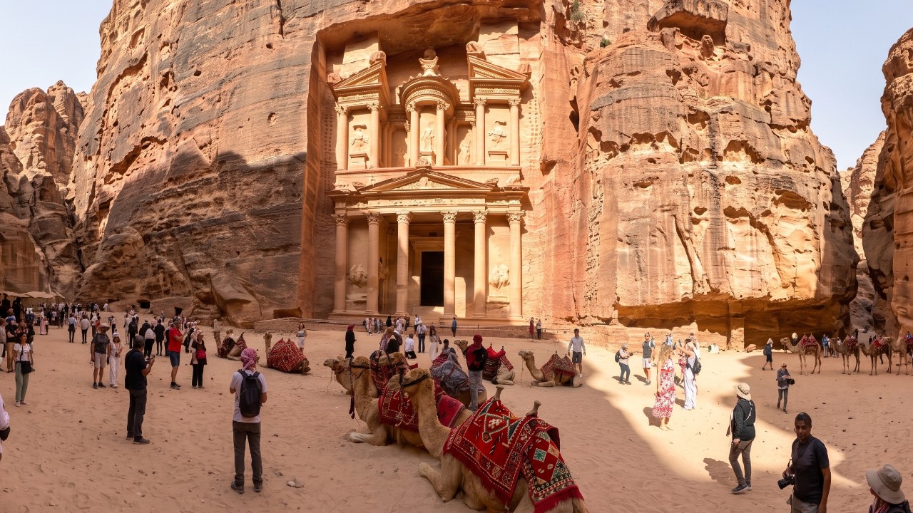
The facades vary from stepped Eastern styles to Hellenistic columnar orders. This is because the Nabataeans were traders who borrowed architectural styles from the diverse cultures they encountered, blending them with local stonemasonry. The Treasury (Al-Khazneh), standing nearly 40 meters high, is the most famous example of this eclectic language. For those who wish to trace this history step-by-step with an expert, Petra Ancient City Historic City Tour offer a narrative that places these facades in their proper chronological context.
Al-Siq: The Gateway to History
Starting from the visitor center, Al-Siq is a narrow rock canyon approximately 1.2 kilometers long, with walls reaching heights of over 90 meters. More than just a walkway, this corridor is a remnant of ancient engineering: the water channels carved by the Nabataeans are still visible along the edges of the path. The ruins of a massive arch at the entrance are remnants of a structure destroyed in the 1896 earthquake. The sudden reveal of the Treasury at the end of the Siq creates the same breathtaking impact today as it did for ancient visitors.
Ad-Deir and the Monumental Upper City
Ad-Deir, or The Monastery, is the largest rock-cut structure in the city, measuring approximately 48 meters wide and 47 meters high. While its design mirrors the Treasury, its ornamentation is simpler, suggesting it was used for ceremonial purposes. Reaching the Monastery requires climbing roughly 800 rock-cut steps; this trek takes over an hour and a half at an average pace, though donkey rentals are available for those preferring a lift.
Reading the City from Above: The Al-Khubtha Trail
Starting near the Royal Tombs, the Al-Khubtha Trail ascends via rock-cut steps to a viewpoint overlooking the Treasury from above. The round trip is about 3 kilometers with an elevation gain of over 300 meters, taking roughly two hours at a relaxed pace. This route is essential for understanding how the city was laid out in the valley and why the tomb facades were aligned in their specific positions.
The Roman Layer, Byzantine Era, and Church Mosaics
After 106 AD, Petra became part of the Roman provincial system, leaving behind legacies like the Colonnaded Street and the theater. During the Byzantine period, churches rose within the city. The most famous is the Byzantine Church Petra, excavated in the 1990s and renowned for its mosaics depicting seasons and animals. In 1993, approximately 140 charred papyrus scrolls were found in a room adjacent to the church. Dated between 537 and 594 AD, these documents prove that Petra remained a functioning settlement long after the Nabataean peak.
The Petra Museum: A Chronological Overview
Opened in 2019 with support from Japan, the Petra Museum is located next to the visitor center. Across eight thematic halls, over 300 artifacts from the Stone Age to the Roman period are displayed chronologically. The focus is on the Nabataean golden age of the 1st century AD and the subsequent Roman layer. Visiting the museum before entering the site makes it much easier to distinguish which century the ruins in the valley belong to. As of the writing of this guide, museum entry is free.
How to Get to Wadi Musa and Petra
The gateway to Petra is the town of Wadi Musa. Travelers from Turkey typically fly into Amman and travel south by road. Turkish citizens are exempt from visas for tourist trips to Jordan, though a valid passport is required.
| Transport Option | Distance & Time | Notes |
|---|---|---|
| Car via Desert Highway (from Amman) | Approx. 235 km, 3 hours | The fastest, most direct route |
| Car via King's Highway (from Amman) | Approx. 274 km, 4-4.5 hours | Scenic route with historical stops |
| Bus from Amman | Scheduled direct service | One-way fare approx. 10 JOD (as of late 2025) |
For visitors wanting to see the history in chronological order, we recommend this sequence:
- Collect your ticket at the visitor center and take a quick tour of the Petra Museum's chronological halls.
- Walk through Al-Siq, following the water channels and rock carvings.
- Stop at the Treasury to examine the Nabataean royal ornamentation.
- Move to the Colonnaded Street and Royal Tombs to explore the Roman layer.
- Depending on your time, choose between the Byzantine Church Petra or the Ad-Deir (Monastery) route.
- If you have energy left, hike up to the Al-Khubtha Trail viewpoint.
For those on a half-day schedule, steps one through three are usually sufficient; One-Day Cultural Tour of Petra typically follow this condensed route.
Pre-Visit Tips
- Multi-day tickets must be used on consecutive days; you cannot skip days.
- Ticket prices are significantly higher for day visitors who do not stay overnight in Jordan; booking accommodation in Wadi Musa can save you money.
- The site is vast and the terrain is rocky throughout; sturdy hiking shoes with good grip are essential.
- The valley heats up quickly in summer; the early morning hours are the coolest and least crowded.
- Bring plenty of water for the Ad-Deir and Al-Khubtha climbs, as there is very little shade on the steps.
Those who wish to distinguish the city's eras through a professional narrative can find a suitable option among the Petra Ancient City Cultural Tours based on their schedule.
Frequently Asked Questions 6
Did the Nabataeans or the Romans build Petra?
The Nabataeans created the city's rock-cut identity. The monumental facades, tombs, and water systems date to the Nabataean period between the 4th century BC and the 1st century AD. The Romans expanded the city with additions like the Colonnaded Street and the theater after the annexation in 106 AD, but they were not the founders.
Are the rock-cut structures tombs or temples?
Most of the large facades are funerary monuments. The Treasury falls into this category; excavation has revealed burial chambers beneath the structure. Some buildings, like Ad-Deir, are believed to have been used for ceremonial purposes, and there are also open-air cult sites like the High Place of Sacrifice.
How did the Nabataeans find and store water in the middle of the desert?
The system consisted of three parts: channels on the slopes collected rainwater, dams diverted sudden flash floods away from the city, and rock-cut cisterns stored the water for the dry months. The channel groove running along the edge of the path in Al-Siq is a visible part of this network today.
What does it mean that Petra is considered a "lost city"?
The city was never completely abandoned, but after the earthquakes of 363 and 551 AD and the shift of trade to sea routes, it lost its regional importance and faded from the knowledge of the Western world. It returned to global prominence when Burckhardt reached the valley in 1812; the term "lost" refers to this long period of invisibility.
What is the best route to see the history in the correct order?
Start with the museum halls, walk through Al-Siq to the Treasury, and then move to the Roman layer at the Colonnaded Street and Royal Tombs. You can then see the Byzantine era at the church ruins and the scale of Nabataean engineering during the climb to Ad-Deir.
Should I visit the Petra Museum before or after the site?
If you think you might struggle to distinguish the eras, take a short tour of the museum first; since the halls are arranged chronologically, it makes it easier to place the ruins you see in the valley. If your time is limited, leave the museum for the end and dedicate the daylight hours to the valley.